
Fall Foliage Map 2026: Real-Time US County Prediction Tracker
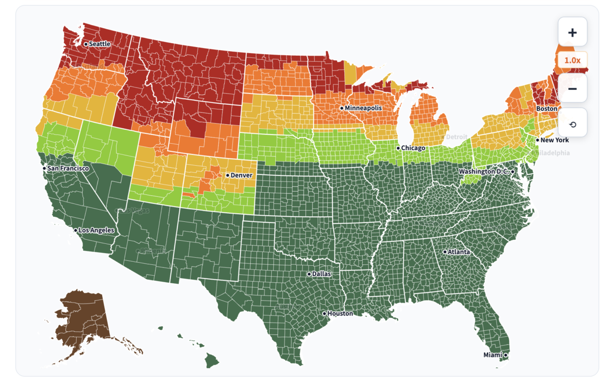
Welcome to the ATL Playbook Fall Foliage Map (2026 Edition) — an interactive US Fall Foliage Prediction Map covering all 3,142 counties across the continental United States. Use our interactive timeline slider to simulate the seasonal progression of autumn colors week by week, or click on any county to reveal its predicted peak week and real-time color status.
🍁 How to Use This Interactive Foliage Tracker
- Click Any County: Tap or click anywhere on the US map to instantly view the county name, state, current color phase, and predicted peak week.
- Timeline Week Slider: Drag the slider from mid-September to mid-November to watch the crimson and gold canopy sweep down from northern latitudes and high alpine summits to the deep South.
- Quick Destination Chips: Jump directly to top leaf-peeping destinations including the North Georgia Blue Ridge, Great Smoky Mountains, Colorado Rockies, and Vermont.
Understanding the 2026 Fall Foliage Map Progression
Unlike countries with uniform geography, the United States experiences autumn colors across an expansive two-month window. Foliage change is triggered by shorter daylight hours and cooler overnight temperatures, beginning in high-elevation alpine zones (such as the Colorado Rockies and White Mountains of New Hampshire) in mid-September, before steadily descending southward into the Midwest, Appalachians, and the Southeast.
When planning a leaf-peeping getaway, elevation and local temperature dips matter far more than fixed calendar dates. A ridge top at 5,000 feet can be at peak crimson while a valley just 15 miles away remains predominantly green.
The 6 Stages of Fall Foliage Explained
Our US Fall Foliage Prediction Map uses a standardized 6-phase color classification model so travelers can identify the optimal window for road trips and photography:
- No Change (Green): Summer green canopy; chlorophyll production remains active.
- Minimal (Lime / 10-20%): Early yellow and amber hints appear at high elevations and branch tips.
- Patchy (Golden / 30-40%): Noticeable mosaic of amber, orange, and red contrasting against green pines and oaks.
- Partial (Orange / 50-60%): Bold autumn color visible across mountain slopes; prime time for scenic drives.
- Near Peak (Red-Orange / 70-80%): Exceptional vibrancy just days away from full transformation.
- 🍁 Peak Foliage (Vibrant Red / 100%): The ultimate travel window where deciduous forests showcase full color saturation.
- Past Peak (Brown / Falling): Leaves fade to bronze and carpet forest floors; ideal for quiet hiking trails.
Regional Fall Foliage Peak Timeline (2026 Calendar)
- Late September to Early October (High Elevation Pioneer Wave): Aspen, Colorado (Maroon Bells); Stowe & Smugglers’ Notch, Vermont; White Mountains, New Hampshire; Minnesota North Shore.
- Early to Mid-October (Northeast & Midwest Peak): Adirondacks & Catskills, New York; Upper Peninsula, Michigan; Pocono Mountains, Pennsylvania; Door County, Wisconsin.
- Mid to Late October (Mid-Atlantic & High Appalachians): Shenandoah National Park (Skyline Drive), Virginia; Eastern Sierra, California; Newfound Gap, Great Smoky Mountains (high ridges).
- Late October to Early November (Southeast Mountain Peak): Blue Ridge, Georgia (pair with nearby Atlanta walking trails for scenic weekend color); Highlands & Cashiers, North Carolina; Gatlinburg & Pigeon Forge, Tennessee; Lost Maples State Natural Area, Texas.
- Mid-November (Southern Metros & Coastal Lowlands): Atlanta Metro & North Georgia lowlands; Congaree National Park, South Carolina; Hill Country, Texas.
3 Essential Field Tips for Leaf Peepers
1. Verify Live Conditions 3 to 5 Days in Advance
Long-range foliage models provide an invaluable planning baseline, but sudden rainstorms, high winds, or unexpected warm spells can shift peak dates by 3 to 5 days. Before heading out, cross-reference with National Park Service (NPS) Foliage Updates and local park webcams.
2. Arrive Early for Mountain Scenic Byways
Corridors like Georgia’s Russell-Brasstown Scenic Byway, the Blue Ridge Parkway, and Virginia’s Skyline Drive experience significant weekend traffic during peak weeks. Aim to pass park entrance gates before 8:30 AM to secure overlook parking.
3. Plan Flexible Elevation Routes
If your primary destination has passed peak or hasn’t started yet, simply travel up or down in altitude. In the Appalachian and Rocky mountain systems, driving 1,500 feet higher or lower can instantly transition you into a completely different stage of autumn foliage.
Frequently Asked Questions (FAQ)
How accurate is the US Fall Foliage Prediction Map?
Our interactive map utilizes historical meteorological data, latitude, elevation coordinates, and deciduous tree species density across 3,142 US counties. While predictive accuracy typically ranges between 80% and 90%, local weather volatility can introduce a 3 to 5-day variance.
When is the best time to see peak fall foliage in Georgia?
In North Georgia (Blue Ridge, Brasstown Bald, Clayton), peak foliage generally arrives between late October and the first week of November. The greater Atlanta metro area typically reaches peak color during the second week of November.
Is it still worth visiting a destination marked as Past Peak?
Yes! In the early days of past peak, forest floors feature stunning leaf carpets, crisp autumn air, and open canopy views that reveal geological formations often hidden during full leaf cover.
Methodology & Data Sources: Foliage progression estimates are modeled using historical climatological datasets from the National Oceanic and Atmospheric Administration (NOAA) and observational reporting guidelines from the U.S. National Park Service (NPS). Predictions are designed for trip planning and educational reference.